Rover Mapping - Consulting services
GIS Strategic Advisory
Custom Discovery workshops and process mapping
Stakeholder collaboration workshops, custom strategic consulting for your organisation
· Establish your geospatial strategy
· Assistance in geospatial resource planning, change management, roadmap adoption
· Ensure organisational readiness for geospatial
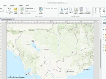
Cartographic Layout Maps
Professional Map Layout exported from GIS software in requested format (PDF, JPEG, PNG or other) and page orientation
Includes geographic analysis and map layer creation upon request
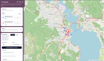
Online web maps
Perfect for public mapping, marketing campaign or map based communications.
Choose from basic public map, enhanced public map or the enterprise mapping system.
· Fully hosted solution – no need to install, configure and maintain software
· QGIS plugin/uploader, Google My Maps and ESRI feature service integration
· Upload of custom data – web map ready in hours not days
· Ability for users to collaborate directly within the web map itself.
· API integration available to feed data into the system gis mapping online mapping software arcgis mapping

GIS Tools
· ESRI Geoprocessing Tools
· QGIS Plugins
· Automate workflows via end user tools in GIS products
· Make GIS products work according to your needs
· Download data, publish data, connect components, automate map production & more

Field Data Collection
· Affordable per user licencing use case
· Collect data in the field – build smart customisable forms (example use cases – weed mapping, tree register mapping, compliance checks)
· GPS receiver connectivity
· Offline access available, sync to cloud when back in the office
· API and command line export tools from cloud environment to on premise servers available
Data Processing and Migration
Incorporate valid data into corporate systems - useful for property, asset management and business ERP systems.
Experience in designing and deploying SAFE Software FME desktop & server workflows
Make better use of QGIS and ESRI platforms with our custom ESRI geoprocessing and QGIS Plugin Tool development

Built environment or design project map
· Fully hosted solution – no need to install, configure and maintain software
· Ability to switch between 2D and 3D map view
· Ability to create simple, digital twins of the built environment. Draw your own 3D buildings in minutes
· Overlay open data sources and upload your own custom GIS data to the map
· Save pre-defined views and camera angles to present data in the most meaningful way
· Community consultation use case also available

Web based reporting
· GIS based report with address or identifier search feature
· Search the answer and view all associated information. Embedded maps in report, great for non-technical users
· PDF export option
· All reports contain URL hyperlinks which can be saved and share for future use
· Enterprise application hosting available

Training
Onsite and Online GIS Training
· Custom courses avaliable for ESRI ArcGIS Pro, QGIS and MapInfo (1 to 2 day courses). Please enquire
Self – guided training
· Development and delivery of app based online GIS training (please enquire)
Geographic Datasets
· Contact us for your data needs – flood data, noise data, air quality data, fire risk data, demographic data (population projections/income/consumer spend)